
Home - Search - Browse - Alphabetic Index: 0- 1- 2- 3- 4- 5- 6- 7- 8- 9
A- B- C- D- E- F- G- H- I- J- K- L- M- N- O- P- Q- R- S- T- U- V- W- X- Y- Z
LAGEOS
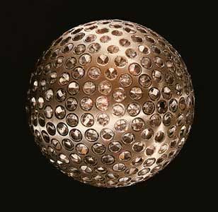 Lageos Credit: Manufacturer Image |
AKA: LAser GEOdynamics Satellite. Status: Operational 1976. First Launch: 1976-05-04. Last Launch: 1992-10-22. Number: 2 . Gross mass: 405 kg (892 lb). Height: 0.60 m (1.96 ft).
By measuring the time between transmission of the beam and reception of the reflected signal from the satellite, stations could precisely measure the distance between themselves and the satellite. These distances could be used to calculate station's positions to within 1-3 cm. Long term data sets could be used to monitor the motion of the Earth's tectonic plates, measure the Earth's gravitational field, measure the "wobble" in the Earth's axis of rotation, and better determine the length of an Earth day.
LAGEOS 1 was developed by NASA and was placed into a high inclination orbit to permit viewing by ground stations located around the world. LAGEOS 2 was a joint program between NASA and the Italian space agency (ASI), which built the satellite using LAGEOS 1 drawings and specifications, handling fixtures, and other materials provided by NASA.
LAGEOS 2's orbit was selected to provide more coverage of seismically active areas, such as the Mediterranean Basin and California, and may help scientists understand irregularities noted in the motion of LAGEOS 1. Ground tracking stations were located in many countries (including the US, Mexico, France, Germany, Poland, Australia, Egypt, China, Peru, Italy, and Japan) and data from these stations was available world-wide to investigators studying crustal dynamics. LAGEOS 1 also contained a message plaque addressed to human and other beings of the far distant future with maps of the Earth from 3 different eras - 268 million years in the past, present day, and 8 million years in the future (the satellite's estimated decay date).
Both satellites were spherical bodies with an aluminum shell wrapped around a brass core. The design was a compromise between numerous factors including the need to be as heavy as possible to minimize the effects of non-gravitational forces; while being light enough to be placed in a high orbit; and the need to accommodate as many retroreflectors as possible; and the need to minimize surface area to minimize the effects of solar pressure. The materials were chosen to reduce the effects of the Earth's magnetic field on the satellite's orbit. 426 cube-corner retroreflectors were imbedded in the satellites' surface. 422 of these were made of fused silica glass while the other 4 were made of germanium. The vehicles had no onboard sensors or electronics, and were not attitude controlled. Science was performed by reflecting laser light from the vehicle's 426 retroreflectors.
More at: LAGEOS.
Family: Earth, Earth geodetic sat, Medium earth orbit. Country: USA. Launch Vehicles: Thor, Delta, Space Shuttle, Delta 2913, Delta 2000. Launch Sites: Cape Canaveral, Vandenberg, Vandenberg SLC2W, Cape Canaveral LC39B. Agency: NASA, Bendix. Bibliography: 2, 279, 6, 6646, 12753.
1976 May 4 - . 08:00 GMT - . Launch Site: Vandenberg. Launch Complex: Vandenberg SLC2W. LV Family: Thor. Launch Vehicle: Delta 2913.
- Lageos - .
Payload: Lageos 1. Mass: 411 kg (906 lb). Nation: USA.
Agency: NASA Huntsville.
Class: Earth.
Type: Geodetic satellite. Spacecraft: Lageos.
USAF Sat Cat: 8820 . COSPAR: 1976-039A. Apogee: 5,947 km (3,695 mi). Perigee: 5,839 km (3,628 mi). Inclination: 109.90 deg. Period: 225.50 min.
LAGEOS (Laser Geodetic Satellite) was a very dense (high mass-to-area ratio) laser retroreflector satellite which provided a permanent reference point in a very stable orbit for such precision earth-dynamics measurements as crustal motions, regional strains, fault motions, polar motion and earth-rotation variations, solid earth tides, and other kinematic and dynamic parameters associated with earthquake assessment and alleviation. The performance in orbit of LAGEOS was limited only by degradation of the retroreflectors, so many decades of useful life can be expected. The high mass-to-area ratio and the precise, stable (attitude-independent) geometry of the spacecraft, together with the orbit, made this satellite the most precise position reference available. Because it is visible in all parts of the world and has an extended operation life in orbit, LAGEOS can serve as a fundamental standard for decades. Additional Details: here....
1992 October 22 - . 17:09 GMT - . Launch Site: Cape Canaveral. Launch Complex: Cape Canaveral LC39B. Launch Platform: MLP3. LV Family: Shuttle. Launch Vehicle: Space Shuttle.
- Lageos 2 - . Payload: Columbia F13 / Lageos 2 [Iris] / CTA. Mass: 400 kg (880 lb). Nation: Italy. Agency: ASI. Class: Earth. Type: Geodetic satellite. Spacecraft: Lageos. USAF Sat Cat: 22195 . COSPAR: 1992-070B. Apogee: 5,952 km (3,698 mi). Perigee: 5,616 km (3,489 mi). Inclination: 52.70 deg. Period: 222.50 min. 60 cm diameter sphere with laser reflectors; deployed from STS-52 10/23/92..
Back to top of page
Home - Search - Browse - Alphabetic Index: 0- 1- 2- 3- 4- 5- 6- 7- 8- 9
A- B- C- D- E- F- G- H- I- J- K- L- M- N- O- P- Q- R- S- T- U- V- W- X- Y- Z
© 1997-2019 Mark Wade - Contact
© / Conditions for Use