
Home - Search - Browse - Alphabetic Index: 0- 1- 2- 3- 4- 5- 6- 7- 8- 9
A- B- C- D- E- F- G- H- I- J- K- L- M- N- O- P- Q- R- S- T- U- V- W- X- Y- Z
SPOT-4
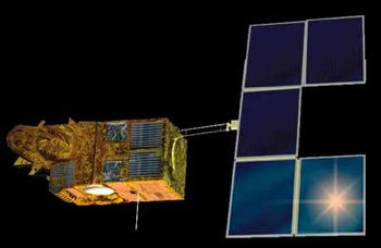 SPOT 4 Credit: Manufacturer Image |
AKA: Satellite Probatoire d'Observation de la Terre. Status: Operational 1998. First Launch: 1998-03-24. Last Launch: 1998-03-24. Number: 1 . Gross mass: 2,755 kg (6,073 lb). Height: 5.40 m (17.70 ft).
Image products from SPOT were sold by a commercial entity, SPOT-Image Corp.
The SPOT-4 spacecraft was 3-axis stabilized, and used a single 5-panel solar array, each panel being 2.6 x 1.9 m. A hydrazine propulsion system provided orbit maintenance.
Two HRVIR (High Resolution Visible - Infrared) push-broom imaging instruments were carried. HRVIR was derived from the HRV instruments on SPOT 1-3. This system provided 10 m resolution in the panchromatic band and 20 m resolution in the multispectral bands. HRVIR included a new medium IR channel to support vegetation analysis and harvest forecasting. The HRVIRs were steerable to within 27 deg off-nadir. Each HRVIR had a swath width of 60 km. The Vegetation Monitoring instrument had 1 km resolution in the same bands as the HRVIR. SPOT-4 also carried the PASTEL optical link terminal supported laser crosslink experiments and DORIS (Doppler Orbitography and Radio positioning Integrated by Satellite) precision orbit determination system. The $ 110 million Silex - semiconductor laser intersatellite link experiment. provided data relay for Artemis.
More at: SPOT-4.
| Helios 1A-1B French military surveillance satellite. Helios 1A an 1B were advanced French military surveillance satellites which were widely believed to have 1 meter resolution capability. Reconnaissance, electro-optical satellite built by ATrospatiale, Matra Marconi for DGA, France. Launched 1995 - 1999. Used the SPOT Mk.2 bus. |
| Envisat European earth resources radar satellite. The European Space Agency's Envisat polar platform was originally envisaged as an automated polar orbiting segment of the Space Station. Earth observation satellite built by Astrium for ESA, Europe. Launched 2002. Used the PPF/SPOT Mk.2 bus. |
Family: Earth, Earth land resource sat, Sun synchronous orbit. Country: France. Launch Vehicles: Ariane, Ariane 4, Ariane 40. Projects: SPOT. Launch Sites: Kourou, Kourou ELA2. Agency: CNES, Matra Marconi, SPOT-Image. Bibliography: 2, 6, 13183.
1995 July 7 - . 16:23 GMT - . Launch Site: Kourou. Launch Complex: Kourou ELA2. LV Family: Ariane. Launch Vehicle: Ariane 40.
- Helios 1A - . Mass: 2,537 kg (5,593 lb). Nation: France. Agency: CNES, DGA. Program: Helios. Class: Surveillance. Type: Military surveillance satellite. Spacecraft Bus: SPOT-4. Spacecraft: Helios 1A-1B. USAF Sat Cat: 23605 . COSPAR: 1995-033A. Apogee: 682 km (423 mi). Perigee: 680 km (420 mi). Inclination: 98.10 deg. Period: 98.40 min.
1998 March 24 - . 01:46 GMT - . Launch Site: Kourou. Launch Complex: Kourou ELA2. LV Family: Ariane. Launch Vehicle: Ariane 40.
- SPOT 4 - .
Mass: 2,755 kg (6,073 lb). Nation: France.
Agency: CNES.
Manufacturer: Toulouse.
Program: SPOT.
Class: Earth.
Type: Earth resources satellite. Spacecraft: SPOT-4.
USAF Sat Cat: 25260 . COSPAR: 1998-017A. Apogee: 826 km (513 mi). Perigee: 824 km (512 mi). Inclination: 98.70 deg. Period: 101.40 min.
Developed by Matra Marconi Space/Toulouse for CNES, the satellite provided 10-m resolution images with a wide field of view. SPOT 4 also carried a wide field 'vegetation' imager and a laser communications experiment. Launch was by an Arianespace Ariane 40 rocket, the base Ariane 4 model with no strap-on boosters. The liquid hydrogen fuelled third stage of the Ariane 40 entered an 800 km sun-synchronous orbit together with SPOT 4.
1999 December 3 - . 16:22 GMT - . Launch Site: Kourou. Launch Complex: Kourou ELA2. LV Family: Ariane. Launch Vehicle: Ariane 40.
- Helios 1B - .
Mass: 2,750 kg (6,060 lb). Nation: France.
Agency: DGA.
Manufacturer: Toulouse.
Program: Helios.
Class: Surveillance.
Type: Military surveillance satellite. Spacecraft Bus: SPOT-4.
Spacecraft: Helios 1A-1B.
USAF Sat Cat: 25977 . COSPAR: 1999-064A. Apogee: 682 km (423 mi). Perigee: 680 km (420 mi). Inclination: 98.20 deg. Period: 98.40 min.
French optical military reconnaisance satellite based on Spot 4. Taken out of service in mid-October 2004, when the orbit of the satellite was lowered to 637 x 640 km, taking it out of the path of Helios 1A and the Helios 2A that would be launched in December 2004.
2002 March 1 - . 01:07 GMT - . Launch Site: Kourou. Launch Complex: Kourou ELA3. LV Family: Ariane 5. Launch Vehicle: Ariane 5G.
- Envisat - .
Mass: 7,991 kg (17,617 lb). Nation: Europe.
Agency: Arianespace.
Class: Earth.
Type: Civilian Radarsat. Spacecraft Bus: SPOT-4.
Spacecraft: Envisat.
USAF Sat Cat: 27386 . COSPAR: 2002-009A. Apogee: 785 km (487 mi). Perigee: 783 km (486 mi). Inclination: 98.60 deg. Period: 100.50 min.
This launch was the first Ariane 5 to use the 17-m Long Fairing and the first to launch north from Kourou. The booster placed the European Space Agency's Envisat polar platform in orbit. The flight profile was quite different from earlier Ariane 5 GTO launches where the EPC core stage usually reached a marginal orbit. In this case EPC separation at 350 km high 10 min after launch. The stage was on a -2610 x 651 km x 93.8 deg orbit, reaching apogee around 0125 UTC and reentering north of Ellesmere Island at about 0136 UTC. The EPS final stage with Envisat only achieved a positive perigee at 22 minutes after launch, with a circular 790 km sun-synchronous orbit reached at 25 min after launch. ESA reported the booster put the satellite to within 20 m of the desired orbital position.
Back to top of page
Home - Search - Browse - Alphabetic Index: 0- 1- 2- 3- 4- 5- 6- 7- 8- 9
A- B- C- D- E- F- G- H- I- J- K- L- M- N- O- P- Q- R- S- T- U- V- W- X- Y- Z
© 1997-2019 Mark Wade - Contact
© / Conditions for Use