
Home - Search - Browse - Alphabetic Index: 0- 1- 2- 3- 4- 5- 6- 7- 8- 9
A- B- C- D- E- F- G- H- I- J- K- L- M- N- O- P- Q- R- S- T- U- V- W- X- Y- Z
STS-99
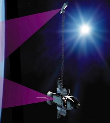 STS-99 Credit: NASA |
AKA: Endeavour;STRM. Launched: 2000-02-11. Returned: 2000-02-22. Number crew: 6 . Duration: 11.24 days.
On an extremely successful mission the space shuttle Endeavour deployed the 61 meter long STRM mast. This was a side-looking radar that digitally mapped with unprecedented accuracy the entire land surface of the Earth between latitudes 60 deg N and 54 deg S. Sponsors of the flight included the US National Imagery and Mapping Agency (NIMA), NASA, and the German and Italian space agencies. Some of the NIMA data would remain classified for exclusive use by the US Department of Defense.
The RSRM-71 solid rocket boosters separated at 17:45 GMT. The OMS engines fired in an OMS Assist maneuver during the ascent to orbit from 17:46 to 17:47 GMT. Main engine cut-off was at 17:52 GMT followed by separation of the ET-92 External Tank. At 18:19 GMT a 2 minute OMS-2 firing placed Endeavour in circular orbit, while the ET coasted to re-entry over the Pacific.
The SRTM mast was deployed successfully at 23:27 GMT on February 12. A failed thruster on the end of the mast caused some work-arounds but did not prevent successful completion of all planned mapping work. After some problems stowing the mast on February 21, Endeavour made a deorbit burn was at 22:25 GMT February 22 and landed at 23:22 GMT. The shuttle Endeavour was then towed to Orbiter Processing Facility Bay 2 to be prepared for the STS-97 mission.
NASA Official Mission Summary
STS-99
Mission: Shuttle Radar Topography Mission
Space Shuttle: Endeavour
Launch Pad: 39A
Launched: February 11, 2000, 12:43:40 p.m. EST
Landing Site: Kennedy Space Center, Florida
Landing: February 22, 2000, 6:22:23 p.m. EST
Runway: 33
Rollout Distance: 9,943 feet
Rollout Time: 62 seconds
Revolution: 181
Mission Duration: 11 days, 5 hours, 39 minutes 41 seconds
Orbit Altitude: 126 nautical miles
Orbit Inclination: 57 degrees
Miles Traveled: 4.1 million
Crew Members: Commander Kevin R. Kregel, Pilot Dominic L. Pudwill Gorie, Mission Specialists Janet L. Kavandi, Janice E. Voss, Mamoru Mohri and Gerhard P. J. Thiele.
Launch Highlights
STS-99 faced a series of launch delays and one scrub before launching successfully. The mission was originally scheduled to fly on Sept. 16, 1999. But in mid-August, the launch date was postponed until October because of wiring concerns throughout the shuttle fleet. With so much of Endeavour's wiring requiring inspection, the target date for launch was shifted to no earlier than Nov. 19. Shuttle managers later decided to preserve the option to launch either STS-99, or STS-103, the third Hubble Servicing Mission, first. It was decided in October that STS-103 would fly first, and the launch of STS-99 was set for Jan. 13, 2000. In December that date came under review, and a new launch date of no earlier than Jan. 31 was set.
The scheduled launch on Jan. 31, 2000, was scrubbed because of unacceptable weather conditions. However, late in the count, an anomaly occurred with the No. 2 enhanced master events controller (EMEC), which also would have prevented the launch on that day. The EMEC was removed and replaced and the launch rescheduled until 12:30 p.m. EST on Feb. 11. About three hours prior to the scheduled launch, an unexpected pressure drop was detected in hydraulic system 1. The pressure drop was determined to be the result of a normal sequence of prelaunch events. Discussions of the pressure drop resulted in a 13-minute, 40-second launch delay.
Mission Highlights
The Shuttle Radar Topography Mission mast was deployed successfully to its full length, and the antenna was turned to its operation position. After a successful checkout of the radar systems, mapping began at 12:31 a.m., less than 12 hours after launch. Crewmembers, split into two shifts so they could work around the clock, began mapping an area from 60 degrees north to 56 degrees south. Data was sent to Jet Propulsion Laboratory for analysis and early indications showed the data to be of excellent quality.
Mapping proceeded fairly smoothly, but during an attitude-hold period for payload mapping during the second day of flight, it was determined that orbiter propellant usage had doubled from 0.07 to 0.15 percent an hour. The increase was caused by a failure of the payload cold-gas thrust system that was used to offset the gravity gradient torque of the mast.
As a result of this failure, orbiter propellant was being used at a higher-than-planned rate to maintain the attitude of the vehicle. Measures to reduce the expenditure were evaluated and based on the analysis, enough propellant could be saved to complete the planned 9-day plus science mission.
The first of a series of "flycast" maneuvers during the mission was also made on the second day of flight. The flycast maneuver was designed to reduce strain on the almost-200-foot mast extending from Endeavour's cargo bay when adjustments to Endeavour's orbit were needed.
The orbiter, which flew tail-first during mapping operations, was moved to a nose-first attitude with the mast extending upward. A brief reaction control system pulse began the maneuver. The mast deflected slightly backwards, then rebounded forward. As it reached vertical, a stronger thrust was applied, arresting the mast's motion and increasing the orbiter's speed.
Radar data gathering concluded at 6:54 a.m. EST on the tenth day of flight after a final sweep across Australia. During 222 hours and 23 minutes of mapping, Endeavour's radar images filled 332 high density tapes and covered 99.98 percent of the planned mapping area -- land between 60 degrees north latitude and 56 degrees south latitude -- at least once and 94.6 percent of it twice. Only about 80,000 square miles in scattered areas remained unimaged, most of them in North America and most already well mapped by other methods. Enough data was gathered to fill the equivalent of 20,000 CD's.
Also aboard Endeavour was a student experiment called EarthKAM, which took 2,715 digital photos during the mission through an overhead flight-deck window. The NASA-sponsored program lets middle school students select photo targets and receive the images via the Internet. The pictures were used in classroom projects on earth science, geography, mathematics and space science. More than 75 middle schools around the world participated in the experiment, which set a record. On four previous flights combined, EarthKAM sent down a total of 2,018 images.
Statistics
STS-99 (97)
- Endeavour OV-105 (14th mission)
- Pad 39-A (68th lauunch)
- 97th Shuttle Mission
OPF -- 12/15/98; VAB -- 7/11/99; PAD -- 12/13/99
Payload:
SRTM, EarthKAM
Mission Objectives:
The Shuttle Radar Topography Mission (SRTM) was an international project spearheaded by the National Imagery and Mapping Agency and NASA, with participation of the German Aerospace Center DLR. Its objective was to obtain the most complete high-resolution digital topographic database of the Earth. SRTM consisted of a specially modified radar system that produced unrivaled 3-D images of the Earth's surface.
SRTM used C-band and X-band interferometric synthetic aperture radars (IFSARs) to acquire topographic data of the Earth's land mass between 60 deg N and 56 deg S. It produced digital topographic map products which met Interferometric Terrain Height Data (ITHD)-2 specifications (30 meter x 30 meter spatial sampling with 16 meter absolute vertical height accuracy, 10 meter relative vertical height accuracy and 20 meter absolute horizontal circular accuracy).
The result of the Shuttle Radar Topography Mission was close to 1 trillion measurements of the Earth's topography. Besides contributing to the production of better maps, these measurements would lead to improved water drainage modeling, more realistic flight simulators, better locations for cell phone towers, and enhanced navigation safety.
Orbit: Altitude: 233 km / Inclination: 57 deg
Data Statistics
- Data Takes Approximately 1,000 (every time Endeavour was over land)
- Data Acquisition more than 80 hours
- Data recording rate 180 Mbits/sec for C-band, 90 Mbits/sec for X-band
- Total Raw Radar Data 9.8 Terabytes (15,000 CDs)
- Data Tapes 300 high-density tapes (each tape records 30 min. of C-band, or 60 min. of X-band data)
In addition, this mission offered a number of applications for data products and science, including: geology, geophysics, earthquake research, volcano monitoring; hydrologic modeling; ecology; co-registration and terrain correction of remotely-acquired image data; atmospheric modeling; flood inundation modeling; urban planning; natural hazard consequence assessments; fire spread models; and transportation/infrastructure planning.
Civilian Applications
Enhanced ground collision avoidance systems for aircraft; civil engineering, land use planning, and disaster recovery efforts; and line-of-sight determination for communications, e.g., cellular telephones.
Military Applications
Flight simulators; logistical planning, air traffic management; missile and weapons guidance systems; and battlefield management, tactics.
Vehicle Data
Shuttle Liftoff Weight: 4,520,415 lbs. Orbiter/Payload Liftoff Weight: 256,560 lbs. Orbiter/Payload Landing Weight: 225,669 lbs.
Payload Weight: SRTM 14.5 tons
Software Version: OI-27
Space Shuttle Main Engines: SSME 1: 2052 SSME 2: 2044 SSME 3: 2047
External Tank: ET-92 ( Super Light Weight Tank)
SRB Set: BI-100/RSRM-71 SRTM Hardware--the Mast Payload Bay
The Mast
Made of carbon fiber reinforced plastic (CFRP), stainless steel, alpha titanium, and Invar, the mast was a truss structure that consisted of 87 cube-shaped sections called bays. Unique latches on the diagonal members of the truss allowed the mechanism to deploy bay-by-bay out of the mast canister to a length of 60 meters (200 feet), about the length of five school buses. The canister housed the mast during launch and landing and also deployed and retracted the mast.
The mast was deployed and retracted by a motor-driven nut within the mast canister. This nut pulled the mast from its stowed configuration and allowed it to unfold like an accordion. An astronaut inside the Space Shuttle initiated the mast deployment. The mast also could have been deployed manually during an EVA using a hand-held motor if necessary.
The mast technology enabled the SRTM system to perform at the high precision necessary to achieve the desired mapping resolution. The mast supported a 360-kilogram antenna structure at its tip and carried 200 kilograms of stranded copper, coaxial, fiber optic cables, and thruster gas lines along its length.
The Shuttle Radar Topography Mission Mast
- Mast Length 60 m
- Nominal Mast Diameter 1.12 m
- Nominal Bay Width at Longerons 79.25 cm
- Nominal Bay Length 69.75 cm
- Number of Bays 87
- Stowed Height/Bay 1.59 cm
- Total Stowed Height 128 cm
The Main Antenna
The main antenna was connected to a pallet that in turn was bolted into the payload bay of the Space Shuttle. The system consisted of two antennas and the avionics that computed the position of the antenna.
Each antenna was made up of special panels that could transmit and receive radar signals. One antenna was the C-band antenna and could transmit and receive radar 5.6 centimeter wavelengths. The second antenna was the X-band antenna. This antenna could transmit and receive 3 centimeter radar wavelengths. Both wavelengths were used in the Spaceborne Imaging Radar C-band/X-SAR missions in 1994 for a variety of environmental studies. The L-band antenna, also used during SIR-C/X-SAR, was removed to save weight.
History/Background
Attitude and Orbit Determination Avionics
In order to map the Earth's topography, SRTM researchers had to:
1) Measure the distance from the Shuttle to some common reference, such as sea-level
2) Measure the distance from the Shuttle to the surface feature over which it was flying
For example, if the Shuttle's height above sea level was known and its respective height above a mountain, then researchers could subtract to get the height of the mountain above sea level.
For the first part, researchers needed to know the Shuttle's height above sea level at all times. NASA needed to constantly measure the Shuttle position to an accuracy of 1 meter (about 3 feet).
For the second part of the formula, SRTM was using radar interferometry to measure the height of the Shuttle above the Earth's surface. One of the biggest challenges in making interferometry work was knowing the length and orientation of the mast at all times. Changes in its length and orientation could have a profound effect on the final height accuracy. Suppose the mast tip moved around by only 2 cm (a bit less than 1 inch) with respect to the Shuttle (this was something that was expected to happen during the mission, due to the astronauts moving around and Shuttle thrusters firing). That doesn't sound like much, but if not taken into account, it would result in a height error at the Earth's surface of 120 meters (almost 400 ft).
Researchers also expected changes in mast length of about 1 cm (about a half-inch) which if not detected would result in additional errors. Therefore, SRTM team members needed to constantly monitor the mast orientation and length. Part of this was measuring where the mast tip was relative to the Shuttle to better than 1 mm (about 4/100th of an inch). The other part was knowing how the Shuttle was oriented relative to the Earth to about 1 arcsec.
To keep track of the Shuttle's position, NASA made use of the Global Positioning System (GPS). Mission managers could do this by combining measurements taken by some specially designed GPS receivers being flown on the Shuttle with measurements taken by an international network of GPS ground receivers.
To measure the mast length and orientation, team members used a variety of optical sensors. A target tracker was used to follow a set of Light Emitting Diode (LED) targets which could be seen on the outboard radar antenna once the mast was fully deployed.
The target tracker also was used to monitor the antenna alignment. There were laptop computers on the Shuttle which displayed the antenna alignment (kind of a cross-hairs with a dot, representing the alignment error). The crew used these displays to guide adjust of some motors at the mast tip (the "milkstool") to remove any alignment errors so the radar could operate properly.
To get the most accurate measure of the mast length, SRTM managers used a set of rangefinders, called Electronic Distance Measurement (EDM) units. To save time and money, the SRTM team decided to buy commercial surveying instruments and modify them for use in space. The rangefinders worked by bouncing a beam of light off a special corner-cube reflector on the outboard antenna and measuring the time to determine the distance.
To measure the orientation of the Shuttle with respect to the Earth, mission managers used one of the most precise star tracker and gyroscope packages ever built. The star tracker looked at the sky and compared what it saw with a star catalogue in its memory to get the attitude of the Shuttle.
EarthKAM In-Cabin
Prime: Kevin Kregel Backup: Dom Gorie
EarthKAM was a NASA-sponsored program that enabled middle school students to take photographs of the Earth from a camera aboard the Space Shuttle. During missions, students worked collectively and used interactive web pages to target images and investigate the Earth from the unique perspective of space.
An electronic still camera (ESC) bracket-mounted to the overhead starboard window of the orbiter aft flight deck faced the nadir to observe various student-selected sites on Earth. Other than equipment setup, initial camera pointing, and possible camera lens changes, no crew intervention was required for nominal operations.
The University of California at San Diego housed the EarthKAM Mission Operations Center (MOC). Most participating schools (or group of schools) establish a Student Mission Operation Center (SMOC) whose computers were connected to the Internet.
Before the mission, students selected a topic of interest, such as human settlement patterns, mountain ranges, or agricultural patterns. Then they defined investigations that were supported by the EarthKAM images.
During the mission, each SMOC submited a number of photo requests through specialized EarthKAM web pages. The requests were processed and uplinked to the EarthKAM ESC aboard the Shuttle.
After the ESC took the pictures, digital images were sent back to Earth and posted on the data system for the students to use in their investigations. For their final reports, students used these new images along with other relevant images from the full EarthKAM image set. Scientists and educators reviewed the original proposal and the final report to provide feedback to the students.
The EarthKAM program also was preparing to mount a camera aboard the International Space Station.
History/Background
During the first four missions of EarthKAM, students took more than 2,000 high-resolution digital images of the Earth. These photographs included the Himalayas, clouds over the Pacific, volcanoes, and recent forest fires in Indonesia.
More at: STS-99.
Family: Manned spaceflight. People: Gorie, Kavandi, Kregel, Mohri, Thiele, Voss, Janice. Country: USA. Spacecraft: Endeavour. Projects: STS. Launch Sites: Cape Canaveral. Agency: NASA, NASA Houston.
2000 February 11 - .
- ISS Status Report: ISS 00-06 - .
Nation: USA.
Program: ISS.
Flight: STS-99.
With no significant issues affecting the on-orbit operation of the International Space Station, managers meeting in Moscow today selected the period from July 8-14 for launch of the Zvezda service module atop a Russian Proton launch vehicle. The ISS Partners formally will be presented the dates for final approval within the next several weeks, in accordance with the ISS Control Board policy. Additional Details: here....
2000 February 11 - .
- STS-99 Mission Status Report #02 - . Nation: USA. Related Persons: Gorie, Kavandi, Kregel, Mohri, Tani, Thiele, Voss, Janice. Program: STS. Flight: STS-99. Space shuttle astronauts deployed the longest rigid structure ever built in space today and continued work to check out the equipment they will use to produce unrivaled three-dimensional images of the Earth's surface.. Additional Details: here....
2000 February 11 - .
- STS-99 - Wakeup Song: Time for Me to Fly - . Flight: STS-99. "Time for Me to Fly" - REO Speedwagon (Blue Team wakeup call).
2000 February 11 - .
- STS-99 Mission Status Report #01 - . Nation: USA. Related Persons: Gorie, Kavandi, Kregel, Mohri, Thiele, Voss, Janice. Program: STS. Flight: STS-99. With six astronauts on board, Endeavour sped to orbit under cloudless skies from the Kennedy Space Center today to begin the Shuttle Radar Topography Mission, the first human space flight of the 21st century.. Additional Details: here....
2000 February 11 - . 17:43 GMT - . Launch Site: Cape Canaveral. Launch Complex: Cape Canaveral LC39A. Launch Platform: MLP3. LV Family: Shuttle. Launch Vehicle: Space Shuttle.
- STS-99 - .
Call Sign: Endeavour. Crew: Gorie,
Kavandi,
Kregel,
Mohri,
Thiele,
Voss, Janice.
Payload: Endeavour F14. Mass: 116,277 kg (256,346 lb). Nation: USA.
Related Persons: Gorie,
Kavandi,
Kregel,
Mohri,
Thiele,
Voss, Janice.
Agency: NASA Houston.
Manufacturer: Boeing.
Program: STS.
Class: Manned.
Type: Manned spaceplane. Flight: STS-99.
Spacecraft Bus: Shuttle.
Spacecraft: Endeavour.
Duration: 11.23 days. Decay Date: 2000-02-22 . USAF Sat Cat: 26088 . COSPAR: 2000-010A. Apogee: 234 km (145 mi). Perigee: 226 km (140 mi). Inclination: 57.00 deg. Period: 89.10 min.
On an extremely successful mission the space shuttle Endeavour deployed the 61 metre long STRM mast. This was a side-looking radar that digitally mapped with unprecedented accuracy the entire land surface of the Earth between latitudes 60 deg N and 54 deg S. Sponsors of the flight included the US National Imagery and Mapping Agency (NIMA), NASA, and the German and Italian space agencies. Some of the NIMA data would remain classified for exclusive use by the US Department of Defense.
2000 February 12 - .
- STS-99 - Wakeup Song: Eye in the Sky - . Flight: STS-99. "Eye in the Sky" - Alan Parsons Project (Blue Team wakeup call).
2000 February 12 - .
- STS-99 Mission Status Report #03 - .
Nation: USA.
Related Persons: Gorie,
Kavandi,
Kregel,
Mohri,
Ross,
Thiele,
Voss, Janice.
Program: STS.
Flight: STS-99.
Endeavour astronauts began mapping operations on the Shuttle Radar Topography Mission, which will provide maps of the Earth unprecedented in accuracy and uniformity. The first swath was begun as the orbiter crossed over southern Asia and continued until Endeavour flew over the continent's eastern coast and moved over the northern Pacific Ocean. The mapping will continue through the mission until the antenna mast is retracted before landing. Additional Details: here....
2000 February 12 - .
- STS-99 Mission Status Report #04 - .
Nation: USA.
Related Persons: Gorie,
Kavandi,
Kregel,
Mohri,
Thiele,
Voss, Janice.
Program: STS.
Flight: STS-99.
By the time members of Endeavour's Red Team had reached lunchtime on this first full day in space for the Shuttle Radar Topography Mission, the radar antennas in the payload bay and at the end of a 200-foot mast had mapped about 1.7 million square miles (4.5 million square kilometers) of the Earth's surface, or the equivalent of about half the area of the United States. Additional Details: here....
2000 February 12 - .
- STS-99 - Wakeup Song: Some Guys Have All The Luck - . Flight: STS-99. "Some Guys Have All The Luck" - Robert Palmer (Red Team wakeup call).
2000 February 13 - .
- STS-99 - Wakeup Song: Linus and Lucy - . Flight: STS-99. "Linus and Lucy" by Vince Guaraldi (Blue Team wakeup call).
2000 February 13 - .
- STS-99 - Wakeup Song: Jumpin' Jive - . Flight: STS-99. "Jumpin' Jive" - Cab Calloway as performed by Joe Jackson (Red Team wakeup call).
2000 February 13 - .
- STS-99 Mission Status Report #06 - .
Nation: USA.
Related Persons: Gorie,
Kavandi,
Kregel,
Mohri,
Tani,
Thiele,
Voss, Janice.
Program: STS.
Flight: STS-99.
The Shuttle Radar Topography Mission's mapping operation continues to run smoothly, with about 17.7 million square miles of the Earth's surface having been mapped by 7 p.m. Central time. Scientists also reported that 38 percent of landmasses had been mapped thus far in the flight. Despite a problem with a small nitrogen thruster on the end of the 200-foot-long mast, both the C-band and X-band radars continue to perform as expected, and the thruster problem has had no impact on mapping operations. Additional Details: here....
2000 February 13 - .
- STS-99 Mission Status Report #05 - .
Nation: USA.
Related Persons: Kavandi,
Kregel,
Thiele.
Program: STS.
Flight: STS-99.
The first "flycast maneuver" trim burn was completed without a hitch by members of the Endeavour crew early Sunday. A little later, the Payload Operations Center reported that the Shuttle Radar Topography Mission had successfully mapped 7.64 million square miles as of very early Sunday morning. Additional Details: here....
2000 February 14 - .
- STS-99 Mission Status Report #07 - .
Nation: USA.
Related Persons: Gorie,
Kavandi,
Kregel,
Mohri,
Thiele,
Voss, Janice.
Program: STS.
Flight: STS-99.
Endeavour crewmembers successfully completed their second "flycast maneuver" trim burn early Monday, as the spacecraft continued to gather data that will greatly improve our topographical knowledge of the Earth's surface. Scientists already have expressed delight with low-resolution "quick look" data, which revealed features not shown on today's best maps. Additional Details: here....
2000 February 14 - .
- STS-99 - Wakeup Song: Journey to the Stars - . Flight: STS-99. "Journey to the Stars" theme song to the popular Japanese anime Galaxy Express - performed by Godiego (Blue Team wakeup call).
2000 February 14 - .
- STS-99 - Wakeup Song: Radar Love - . Flight: STS-99. "Radar Love" - performed by Golden Earring (Red Team wakeup call).
2000 February 14 - .
- STS-99 Mission Status Report #08 - .
Nation: USA.
Related Persons: Gorie,
Kavandi,
Kregel,
Mohri,
Thiele,
Voss, Janice.
Program: STS.
Flight: STS-99.
"As excited as a kid on Christmas day" is how Shuttle Radar Topography Mission project engineer Ed Caro described his reaction to the progress of the radar-mapping mission thus far. Operations onboard Endeavour continued without interruption, even without the availability of a small nitrogen thruster on the end of the extended boom. By midday, about 24 million square miles had been mapped once, and 9 million square miles twice. That's more than half the planned coverage for the mission. Additional Details: here....
2000 February 15 - .
- STS-99 Mission Status Report #10 - .
Nation: USA.
Related Persons: Gorie,
Kavandi,
Kregel,
Mohri,
Thiele,
Voss, Janice.
Program: STS.
Flight: STS-99.
New radar images of Brazil, South Africa and the South Island of New Zealand were unveiled this afternoon by elated scientists of the Shuttle Radar Topography Mission. "This snapshot of Earth will be used for decades to come," said deputy project scientist Dr. Tom Farr. Additional Details: here....
2000 February 15 - .
- STS-99 - Wakeup Song: Canon in D - . Flight: STS-99. "Canon in D" by Johann Pachebel - as performed by George Winston (Blue Team wakeup call).
2000 February 15 - .
- STS-99 - Wakeup Song: New York, New York - . Flight: STS-99. "New York, New York" - performed by Frank Sinatra (Red Team wakeup call).
2000 February 15 - .
- STS-99 Mission Status Report #09 - . Nation: USA. Related Persons: Gorie, Kavandi, Kregel, Mohri, Thiele, Voss, Janice. Program: STS. Flight: STS-99. Endeavour astronauts had completed mapping well over half the targeted Earth land surface by early Tuesday, and scientists continued to express delight at the quality of information they were seeing.. Additional Details: here....
2000 February 16 - .
- STS-99 Mission Status Report #12 - .
Nation: USA.
Related Persons: Gorie,
Mohri,
Thiele,
Voss, Janice.
Program: STS.
Flight: STS-99.
With growing confidence that fuel-saving measures onboard Endeavour will permit the radar mapping mission to run its full duration, flight controllers and crew members today marked the mission's mid-way point. "We're almost there," stated Milt Heflin, NASA's Deputy Chief Flight Director. Additional Details: here....
2000 February 16 - .
- STS-99 - Wakeup Song: Smack Dab in the Middle - . Flight: STS-99. "Smack Dab in the Middle" - performed by Ray Charles (Red Team wakeup call).
2000 February 16 - .
- STS-99 - Wakeup Song: We Saw the Sea - . Flight: STS-99. "We Saw the Sea" - performed by The Naval Academy Glee Club (Blue Team wakeup call).
2000 February 16 - .
- STS-99 Mission Status Report #11 - .
Nation: USA.
Related Persons: Gorie,
Kavandi,
Kregel,
Mohri,
Thiele,
Voss, Janice.
Program: STS.
Flight: STS-99.
Optimism in orbit and in Mission Control that Endeavour will have enough propellant and power to complete its planned mapping of more than 70 percent of the Earth's surface continues to increase. Mission Control also told the astronauts that the EarthKAM aboard Endeavour has successfully transmitted its 1,000th image for middle school students. Additional Details: here....
2000 February 17 - .
- STS-99 Mission Status Report #13 - .
Nation: USA.
Related Persons: Gorie,
Kavandi,
Kregel,
Mohri,
Thiele,
Voss, Janice.
Program: STS.
Flight: STS-99.
Masses of data that will result in topographical maps far better than any now available continue to flow into high-rate recorders as Endeavour enters the second half of its Shuttle Radar Topography Mission. Efforts to conserve propellant and power continue to pay off, with officials gaining more confidence that the entire nine days, nine hours of mapping operations will be completed. Additional Details: here....
2000 February 17 - .
- ISS Status Report: ISS 00-07 - .
Nation: USA.
Program: ISS.
Flight: STS-99.
As the International Space Station continues to orbit the Earth in good shape, its automatic docking system was tested twice this week without problems in an effort to verify that the system is ready to support the rendezvous with the Zvezda service module this summer. Meanwhile, Space Shuttle and Station managers formally approved the Shuttle visit to the Station to outfit Zvezda for occupancy by the first resident crew. Additional Details: here....
2000 February 17 - .
- STS-99 - Wakeup Song: Die Moldau - . Flight: STS-99. "Die Moldau" - performed by The Boston Symphony Orchestra (Red Team wakeup call).
2000 February 17 - .
- STS-99 - Wakeup Song: Take a Little Less - . Flight: STS-99. "Take a Little Less" - performed by Barton and Sweeney (Blue Team wakeup call).
2000 February 17 - .
- STS-99 Mission Status Report #14 - .
Nation: USA.
Related Persons: Gorie,
Hadfield,
Kavandi,
Mohri,
Voss, Janice.
Program: STS.
Flight: STS-99.
Propellant conservation measures have paid off and Endeavour's crew was notified this morning that the mapping operations will continue for the full nine days as planned prior to launch. "That's great news," replied Pilot Dom Gorie. "They're getting some fantastic data on this mission." Additional Details: here....
2000 February 18 - .
- STS-99 Mission Status Report #15 - .
Nation: USA.
Related Persons: Gorie,
Kavandi,
Kregel,
Mohri,
Thiele,
Voss, Janice.
Program: STS.
Flight: STS-99.
With unprecedented detail of well over half of the world's terrain already safely stored aboard, Endeavour's crew continued mapping the Earth uninterrupted this morning, marching toward more than nine full days of radar observations thanks to successful fuel conservation measures. Additional Details: here....
2000 February 18 - .
- STS-99 Mission Status Report #16 - .
Nation: USA.
Related Persons: Hadfield,
Kregel.
Program: STS.
Flight: STS-99.
Mission managers late this afternoon announced a nine-hour extension to the data-taking portion of the mission. That means that mapping of the Earth now will continue until about 6 a.m. Monday. Astronaut Chris Hadfield in Mission Control relayed the good news shortly before 4 p.m. to Commander Kevin Kregel and the rest of Endeavour's crew. "That's super news," Kregel replied. "I'm sure the folks at the Jet Propulsion Lab and NIMA are really ecstatic about that." Additional Details: here....
2000 February 18 - .
- STS-99 - Wakeup Song: Magic Carpet Ride - . Flight: STS-99. "Magic Carpet Ride" - performed by Steppenwolf (Red Team wakeup call).
2000 February 18 - .
- STS-99 - Wakeup Song: Rawhide - . Flight: STS-99. "Rawhide" - performed by Frankie Laine (Blue Team wakeup call).
2000 February 19 - .
- STS-99 Mission Status Report #18 - .
Nation: USA.
Related Persons: Kregel,
Mohri,
Thiele.
Program: STS.
Flight: STS-99.
Following yesterday's decision by mission managers to extend mapping operations, Endeavour's astronauts are set to continue collecting data until 5:44 a.m. Central time Monday. At that point preparations will begin to stow the 200-foot-long mast for the remainder of the mission. This 9-hour extension allows for almost 100 percent of the planned coverage of the Shuttle Radar Topography Mission. Additional Details: here....
2000 February 19 - .
- STS-99 Mission Status Report #17 - .
Nation: USA.
Related Persons: Gorie,
Kavandi,
Kregel,
Mohri,
Thiele,
Voss, Janice.
Program: STS.
Flight: STS-99.
The EarthKAM, a digital camera mounted at an overhead window on Endeavour's flight deck, continues its record setting pace. A little after 4 a.m. CST Saturday flight controllers reported it had sent down more than 2,018 images, the combined total of the four previous flights on which it had flown. Additional Details: here....
2000 February 19 - .
- STS-99 - Wakeup Song: One after 909 - . Flight: STS-99. "One after 909" - performed by The Beatles (Blue Team wakeup call).
2000 February 19 - .
- STS-99 - Wakeup Song: Catch the Moments As They Fly By - . Flight: STS-99. "Catch the Moments As They Fly By" - Traditional Celtic Music - Shannon River Dance (Red Team wakeup call).
2000 February 20 - .
- STS-99 - Wakeup Song: Walk Don't Run - . Flight: STS-99. "Walk Don't Run" -California Guitar Trio (Red Team wakeup call).
2000 February 20 - .
- STS-99 Mission Status Report #20 - .
Nation: USA.
Program: STS.
Flight: STS-99.
Earth radar mapping continues smoothly on its last full day with Endeavour's crew scheduled to wrap up operations early Monday morning at 5:53 Central Time. As of noon today, 99 percent, or about 47 million square miles of the target area had been mapped once. More than 87 percent of the target area - nearly 42 million square miles - has been mapped twice. Additional Details: here....
2000 February 20 - .
- STS-99 Mission Status Report #19 - .
Nation: USA.
Related Persons: Gorie,
Kavandi,
Kregel,
Mohri,
Ross,
Thiele,
Voss, Janice.
Program: STS.
Flight: STS-99.
Endeavour's astronauts are looking forward to using one more small bonus in mapping operations time. They were given an additional 10 minutes, bringing the total to nine days, 18 hours and 10 minutes. The additional minutes have been added to allow one more mapping pass across Australia, rather than turning off the radar just as the spacecraft approaches the nation's coastline. Additional Details: here....
2000 February 21 - .
- STS-99 Mission Status Report #21 - .
Nation: USA.
Related Persons: Ross.
Program: STS.
Flight: STS-99.
Endeavour's astronauts finished their successful Shuttle Radar Topography Mission mapping operations early Monday, then retracted the system's 200-foot mast into its payload bay canister. The mast, the longest rigid structure ever deployed in space, supported the external antenna structure during more than 222 hours of data gathering that mapped almost 100 percent of all planned sites around the world. Additional Details: here....
2000 February 21 - .
- STS-99 Mission Status Report #22 - . Nation: USA. Related Persons: Gorie, Kavandi, Kregel, Mohri, Ross, Thiele, Voss, Janice. Program: STS. Flight: STS-99. With mapping operations complete and Endeavour's radar mapping hardware stowed, astronauts today conducted checks of various flight control surfaces and thruster jets in preparation for tomorrow's return to Earth.. Additional Details: here....
2000 February 21 - .
- STS-99 - Wakeup Song: Stay - . Flight: STS-99. "Stay" Frankie Valli & Four Seasons (Blue Team wakeup call).
2000 February 22 - .
- STS-99 Mission Status Report #23 - .
Nation: USA.
Program: STS.
Flight: STS-99.
Endeavour's crew is preparing for a return home today, working toward a touchdown at the Kennedy Space Center, Florida, at 3:50 p.m. CST, the first of three landing opportunities. A second opportunity to land in Florida is available with a touchdown at 5:22 p.m. CST. Endeavour also may land at Edwards Air Force Base, California, with a touchdown at 6:48 p.m. CST. Additional Details: here....
2000 February 22 - .
- STS-99 Mission Status Report #24 - . Nation: USA. Related Persons: Gorie, Kavandi, Kregel, Mohri, Ross, Thiele, Voss, Janice. Program: STS. Flight: STS-99. The six astronauts aboard Space Shuttle Endeavour glided to a smooth landing at the Kennedy Space Center at sunset today, wrapping up their 11-day radar mapping mission, the first human space flight of the 21st century.. Additional Details: here....
2000 February 22 - .
- Landing of STS-99 - . Return Crew: Gorie, Kavandi, Kregel, Mohri, Thiele, Voss, Janice. Nation: USA. Related Persons: Gorie, Kavandi, Kregel, Mohri, Thiele, Voss, Janice. Program: STS. Flight: STS-99. STS-99 landed at 23:22 GMT. .
Back to top of page
Home - Search - Browse - Alphabetic Index: 0- 1- 2- 3- 4- 5- 6- 7- 8- 9
A- B- C- D- E- F- G- H- I- J- K- L- M- N- O- P- Q- R- S- T- U- V- W- X- Y- Z
© 1997-2019 Mark Wade - Contact
© / Conditions for Use